Tag: IRNSS

  • Private sector enters satellite building with ‘IRNSS replacement’ launch today

    Private sector enters satellite building with ‘IRNSS replacement’ launch today

    MUMBAI: India’s success in space exploration has been growing tremendously.

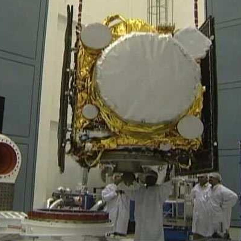
    One of the seven satellites in the constellation, as three rubidium atomic clocks on board had stopped functioning, the IRNSS- 1H satellite, weighing 1,425kg, will be launched from the second launch pad of the Satish Dhawan Space Centre at Sriharikota (Andhra Pradesh), on the ISRO’s launch vehicle PSLV-XL.

    The launch of India’s eighth navigational satellite IRNSS- 1H scheduled at 19:00 hrs today will mark the first time the private sector got actively involved in assembling and testing of a satellite. In the past, the private sector has supplied components for satellites, it has now been involved in the actual assembly.

    The Indian Regional Navigation Satellite System (IRNSS) is an independent regional navigation satellite system developed by India on par with US-based GPS. The system that offers services like terrestrial and marine navigation, disaster management, vehicle tracking and fleet management, navigation aide for hikers and travellers, visual and voice navigation for drivers, was named ‘NavIC’ (Navigation with Indian Constellation) by the prime minister Narendra Modi.

    The launch vehicle PSLV-C39 will use the ‘XL’ version of PSLV equipped with six strap-ons, each carrying 12 tons of propellant.

    ISRO chairman S Kiran Kumar said that a private company was for the first time involved in the integration of a satellite. Progressively, more such companies would be involved, he added. Subsystems of the payload and launch vehicle were being developed in collaboration with the industry, Kumar said.

    Around 25 per cent of the IRNSS-1H development work was successfully completed by a consortium led by Bengaluru-based Alpha Design Tecnologies, under the guidance of ISRO scientists.

    The need to launch this satellite came up after three atomic clocks on board ISRO’s first navigational satellite IRNSS-1A, launched in 2013, had stopped functioning. Imported from European aerospace manufacturer Astrium, the clocks are used to provide accurate locational data used in several earth-based applications, such as navigation and monitoring.

    The IRNSS-1H will be launched into a sub geosynchronous transfer orbit after which two solar panels of the satellite will be automatically deployed, and the master control facility at Hassan will perform orbit raising manoeuvres of the satellite.

    NavIC is useful for merchant ships in navigation and also during search and rescue operations. NavIC helps commuters to traverse distances and also enable transport operators to track their vehicles. The system is also helpful for railways in tracking trains and also giving an alert in the case of unmanned level crossing.

    NavIC is also used for other applications like location-based services, survey and alignment, time synchronised services. It provides two types of services — standard positioning service and restricted service.

  • ISRO launches India’s fifth navigation satellite IRNSS-1E

    ISRO launches India’s fifth navigation satellite IRNSS-1E

    MUMBAI: The Indian Space Research Organisation’s (ISRO) Polar Satellite Launch Vehicle, PSLV-C31, successfully launched the 1425 kg IRNSS-1E, the fifth satellite in the Indian Regional Navigation Satellite System (IRNSS) on the morning of 20 January, 2016 from Satish Dhawan Space Centre SHAR, Sriharikota.


    This is the 32nd consecutively successful mission of PSLV and the 11th in its ‘XL’ configuration.


    After the PSLV-C31 lift-off at 0931 hrs (9:31 am) IST from the Second Launch Pad with the ignition of the first stage, the subsequent important flight events, namely, strap-on ignitions and separations, first stage separation, second stage ignition, heat-shield separation, second stage separation, third stage ignition and separation, fourth stage ignition and satellite injection, took place as planned. After a flight of about 18 minutes 43 seconds, IRNSS-1E Satellite was injected to an elliptical orbit of 282.4 km X 20,655.3 km inclined at an angle of 19.21 degree to the equator (very close to the intended orbit) and successfully separated from the PSLV fourth stage.


    After injection, the solar panels of IRNSS-1E were deployed automatically. ISRO’s Master Control Facility (at Hassan, Karnataka) took over the control of the satellite. In the coming days, four orbit manoeuvres will be conducted from Master Control Facility to position the satellite in the Geosynchronous Orbit at 111.75 deg East longitude with 28.1 deg inclination.


    IRNSS-1E is the fifth of the seven satellites constituting the space segment of the Indian Regional Navigation Satellite System. IRNSS-1A, 1B, 1C and ID, the first four satellites of the constellation, were successfully launched by PSLV on 2 July, 2013, 4 April, 2014, 16 October, 2014 and 28 March, 2015 respectively. All the four satellites are functioning satisfactorily from their designated orbital positions.


    IRNSS is an independent regional navigation satellite system designed to provide position information in the Indian region and 1500 km around the Indian mainland. IRNSS would provide two types of services, namely, Standard Positioning Services (SPS) – provided to all users – and Restricted Services (RS), provided to authorised users.


    A number of ground stations responsible for the generation and transmission of navigation parameters, satellite ranging and monitoring, etc., have been established in eighteen locations across the country. In the coming months, the remaining two satellites of this constellation, namely, IRNSS-1F and IG, are scheduled to be launched by PSLV, thereby completing the entire IRNSS constellation.